“Safety third” names the gap between what we say matters and what streets actually deliver. This idea resonates in Falls Church, where we are seeing more injuries and growing calls for better streets. For this years’ traffic injury analysis, we look back at a decade of traffic injuries and street projects. Have we deprioritized safety in favor of attracting more cars, seeking consensus, and politics? Are we letting VDOT’s influence (not control) scare us into living with dangerous main streets? We hope 2025 was our turning point.
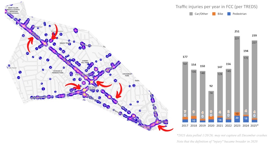
This data is from Traffic Records Electronic Data System (TREDS), the State of Virginia's "one-stop-shop" to provide accurate, timely and detailed highway safety information. The image above is a heatmap of all road injuries in Falls Church 2017-2025 and the trend over time. We ask that the City (1) conduct Safety Audits together with the community and take rapid action at the locations with arrows and (2) pause the NTC program for a few years and instead deploy a scale, consistent, affordable approach to quickly retrofit our risky secondary streets with low-cost materials. Less negotiation and bespoke design, more repeatability and economy of scale.
The detail:
Safety and return on investment do not appear to be our state or local priorities in transportation. Setting aside planning documents or public statements and just looking at a decade of project locations and designs vs. where injuries occur, our top priorities appear to have been:
More cars - encouraging more people to drive here via parking minimums, extensive free street parking, action to minimize traffic backups, etc.
Consensus - avoiding disagreement with neighbors, snowplowing team, VDOT, NOVA Parks, Arlington, Fairfax, etc. even when that’s more dangerous
Politics - time and money spent where people have influence, not necessarily where people are getting hurt
People get hurt in the same places year after year and the number is going up. We spend months discussing people’s interests but only days or weeks taking action for safety. Our safety outcomes are weaker because many projects are placed by politics and are designed for consensus not safety.
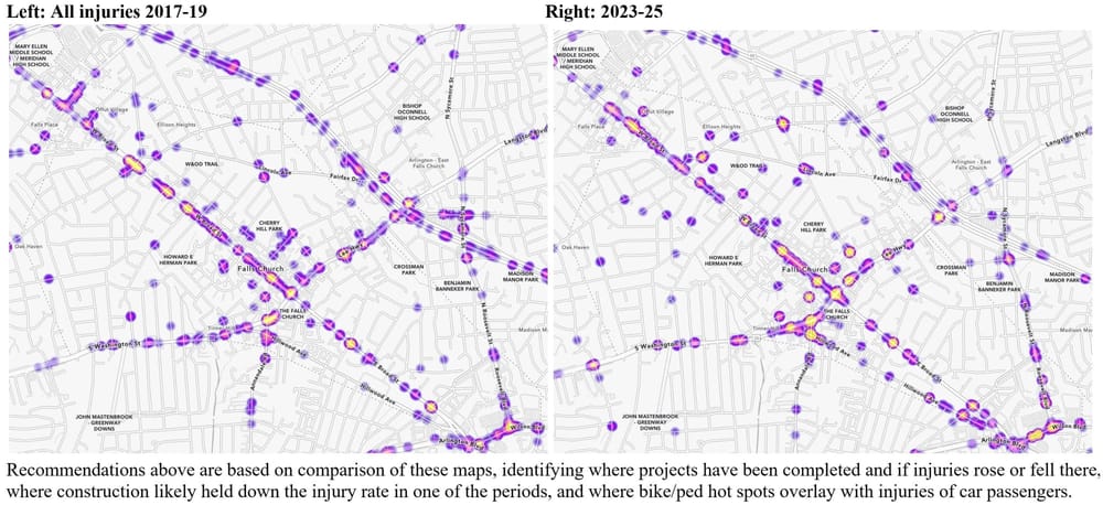
Looking at the locations of crashes 2017-19 vs 2023-25, we see a few problems:
More injuries on Broad and on Washington, where what was once a road (for primarily through traffic by cars) is trying to be a street (for accessing ever-more residences and business, by multiple travel modes) and thus can be considered “stroads” which are known for being dangerous
More injuries on secondary street intersections following a trend of more cut-through traffic post COVID and I-66 tolls
Traffic calming on streets with no injuries, where it can take years to go from a neighbor’s ask to installation of a few speed bumps or plastic poles
Comparing the decade of our injury data with the projects done during that time suggests that what works to reduce injuries is:
NACTO-like designs: Urban cross-sections with narrow streets, tight intersections, restrictions on dangerous turns, street trees, clear sight lines, less ability to drive on autopilot, less empty parking lanes, and places to bike and walk → there were fewer injuries on Lincoln Ave (at placed narrowed by medians), Park and Lee (4-way stop), Park and Virginia (narrower road w/ new library), Little Falls and Great Falls (curb extensions, now a stop), etc.
Construction: Injuries fell when there was construction in ‘23-25 as closed lanes, narrow lanes, and poor road surfaces slowed speeds and encouraged attention → Haycock Rd (West Falls), W&OD crossings (Dual Trails), West and Broad (Founders Row), Little Falls at City Hall (crumbling road)
What we can do if safety and ROI are our priorities:
Less planning, more doing: Redirect time/money from consensus-driven NTC to data-driven tackling of high-crash intersections and changes that can be implemented at scale (e.g., paint “20 mph zone” on all streets abutting Broad or Washington, add speed bumps to all streets with significant pedestrian destinations like Annandale Road and N West St, add paint-and-posts curb extensions at all intersections that average >1 injury per year).
Safety Audits: Staff, police, and community members review crash data, visit high-crash locations and design immediate actions to address the following locations, not letting “VDOT” scare us out of even trying to address the roads we maintain, control, and live (and occasionally die) on
N Washington St from Broad St to Great Falls St (walkable core crossing over busy 30mph stroad)
Wilson Blvd and N Roosevelt St (Eden Center community)
N Washington St - Annandale Road - Hillwood Ave - Fairfax Dr (getting worse, one of the least ped/bike-friendly areas in the City)
E Broad St and Cherry St (car/bike/ped hot spot - key route to Metro and the W&OD)
Park Ave - N West St - Grove Ave hotspot (as recommended by CACT - key walking route to school)
W Broad St from Falls Ave to Gordon Road (worsening hot spot on walking route to school)
Safe Routes to School Coordinator: Designate a passionate individual at the schools with responsibility for transportation safety (walking and biking routes, car drop off & pickup) who liaises with the Police and City Staff to get immediate action for high-risk spots on routes to school
Monitor outcomes of projects that, if successful, will address historic hot spots: S Maple and Annandale Road roundabout, Wallace St and S Maple sidewalks/crosswalks, N Washington and E Columbia new signal and sidewalks/crosswalks, S West and Ellison curb extension and crosswalks
Prioritize critical transportation safety projects: N Washington St Multi-Modal, NVTA grant for Washington-Annandale-Hillwood, Bike Master Plan Complete Streets projects (Route to School, N/S West St, Park Ave), E Broad St Road Diet, and Wilson Blvd Complete Streets address high-risk areas
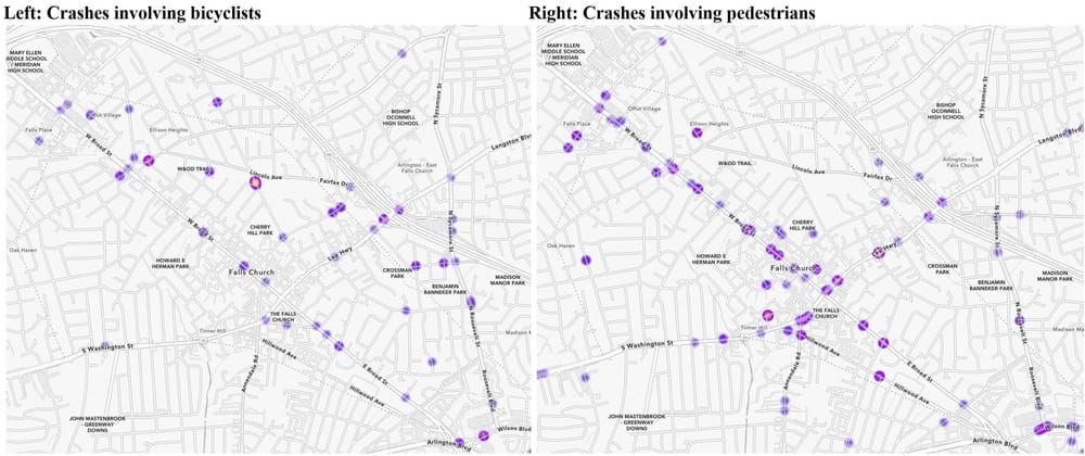
Recommended quick-win hot spot actions uniquely for:
Bicycling:
Convert W&OD and Great Falls to a 4-way stop (most dangerous crossing on entire W&OD, had a temporary slowdown in injuries during Dual Trails construction). Along the entire W&OD, there are almost never injuries at crossings with stop signs for the road.
Review West, Grove, Park area per CACT request and revisit adding a 4-way stop at Grove Ave and W&OD and painting the crosswalk background red to match other W&OD crossings in the City
Add bike boxes (waiting area in front of cars) at signalized intersections crossing Broad or Washington, e.g., Cherry St and E Broad St
Walking:
Add crosswalk at Gundry Dr and James St (similar to the one added at James and Virginia in 2018/19)
Monitor results of projects in hot spots and deeply assess any injuries: (1) Wallace St and S Maple sidewalks and crosswalk, (2) Columbia & N Washington rebuilt intersection, (3) HAWK signals on Broad at Oak and Fairfax, (4) expanded no turn on red on Broad St (especially at Annandale Road), and (5) added crosswalks on Hillwood Ave