
Building a Bike-Friendly Future in Falls Church
At Bike Falls Church, we recently reviewed the 2025 Bike Master Plan (BMP), all 50+ streets and paths, and compared it to the City’s capital projects, paving schedule, and neighborhood traffic programs.
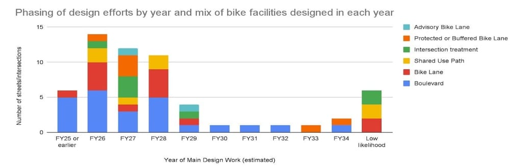
The findings are inspiring: Falls Church has the means to complete a citywide All Ages and Abilities (AAA) Bike Network by 2035 and most the design work for that network will occur in the next 3 years: 2026-2028.
We’ve shared a roadmap with the Department of Public Works (DPW) to help guide workplans, budgets, grant applications, and design priorities. With steady leadership and community commitment, we can build a city where every resident, from kids to commuters, has a safe, efficient, and comfortable way to get around without a car.
1. Seize Every Opportunity
Between the City’s Capital Improvement Plan (CIP), Neighborhood Traffic Calming (NTC) program, and regular paving schedule, nearly every Bike Master Plan route will be touched by 2035 and most of the design work will happen in the next few years.
This is our window.
We’re asking City staff to make “all ages and abilities” the default standard for every street project and to seek public input when that standard can’t be met. Many neighborhood streets can be upgraded to bike boulevards with simple traffic calming and clear signage.
By designing for people we can make steady, cost-effective progress toward a safer, more connected bike network.
2. Lean In on the Tricky Spots
A few roads and intersections will require tough choices and collaboration to make them safe for everyone. These are the places where leadership and advocacy matter most.
Key focus areas include:
East-West Route to Secondary Campus (in design)
North/South West Street (FY26 workplan)
Park Avenue west of Virginia Avenue (late 2020s)
East Broad Street (engineering study kicking off in late 2025)
Great Falls Street (NTC program + Lincoln Ave Phase C/D alternative)
Annandale / Hillwood / Washington area (NVTA grant application submitted)
South Oak & Marshall Streets (CACT's memo on safety)
These projects will shape the comfort and connectivity of the network for decades. Let’s make sure they meet the “all ages and abilities” standard our community deserves.
3. Accelerate with Quick-Build Projects
Not every improvement needs a full rebuild. With modest funding and dedicated staff time, Falls Church can launch a Quick-Build Program to deliver safer streets now — especially on routes not scheduled for repaving before the 2030s.
Examples include:
Bike Route Sign Refresh: Update the outdated 2013 signs to reflect today’s safest routes.
Sharrow Network: Add targeted sharrows at intersections to help riders navigate bike boulevards.
Bike Lane Blitz: Paint and post new bike lanes on low-traffic streets with minimal parking impact.
Quick win spots:
Hillwood Avenue: Upgrade existing lanes to buffered or parking-protected bike lanes, extend bike lanes to S Cherry St, and install safer intersection features.
North Spring Street: Add a contraflow lane from Park to Broad — a key route to Oak Street Elementary.
South Maple Avenue: Replace the center turn lane with buffered or protected bike lanes.
Gordon Road & Birch Avenue: Narrow over-wide car lanes and add bike lanes.
Sidewalk Missing Links: Complete short but important pedestrian connections like the Greenway Downs paper street and Villa Ridge Road end. Consider when extra-wide sidewalks can serve as the best feasible bike infrastructure (e.g., along Roosevelt St).
Each of these small projects adds up — making Falls Church safer, more accessible, and more livable.
4. Tracking Progress and Staying Accountable
Bike Falls Church will track progress toward the Bike Master Plan 2035 vision, monitor project timelines, and advocate for meaningful outcomes.
The next few years are especially critical — 2026-2028 will see design work for many key routes, including repaving near Oak Street Elementary, bike lanes on West Street, and studies on East Broad, Great Falls, and Annandale/Washington.
What happens now determines whether our city builds a bike network that truly works for everyone.
Riding into the 2030s with Confidence
Falls Church has the opportunity — and the plan — to become a Bike Friendly Community in every sense of the term.
If we seize opportunities, lean in on challenges, and support quick-build improvements, we can go into the 2030s confident that we’ve built a safer, healthier, and more connected city.
Let’s keep pushing forward — together. Every bike lane, every crosswalk, every safer intersection gets us closer to the vision: a city where it’s safe to ride anywhere, anytime, at any age.
Street-by-Street Assessment
Detail by street: Each street/intersection in the Bike Master Plan is listed three elements. In the list below the streets are organized into groups by size and by three zones of the City.
Car Speed & Volume: Based on posted limit with “>” if speeding is a known problem, Average Daily Traffic (ADT) volume per Virginia Department of Transportation (VDOT).
Target Bike Facility: This is based on the National Association of City Transportation Officials’ (NACTO’s) “All Ages and Abilities” criteria based on car speed and volume but is pragmatic based on other needs and costs (e.g., right of way, utilized street parking, cost to move curbs, etc.). The colored dots indicate if the proposed bike facility meets NACTO’s criteria (green), meets during some times of day or close (yellow), or is not close to suitable for “all ages and abilities” (red).
Means and Timing: The colored dots indicate if it is in the budget or paving plan already (green), is a low-cost addition to the budget/plan in future years (yellow), or is a major/expensive project which may or may not happen by 2035 (red). Some projects are more aspirational and require either redevelopment or successive property acquisition - these are listed but are not assumed to be completed by 2035. Alternative, lower cost routes are included in the list to meet the 2035 goal. Dates below reflect construction and are later than the design timing dates in the chart above.
Street / Intersection | Car Speed & Volume | Target Bike Facility | Means and Timing |
Off-Street Trails and Paths | |||
Route to Secondary Schools (West End Park, Falls Ave, Offutt Dr, behind Giant) | 20mph | 🟢Off-street path in West End Park and between Gates and Falls Plaza condos. Bike boulevard for Falls Ave, Offutt Drive | 🟢BMP Phase 1: Local or grant CIP, planned in FY26, constructed by FY30 |
Gordon Triangle Birch St extension | Likely 20mph, >2k ADT | 🟢Bike lanes and protected intersections | 🔴Development |
Greenway Downs Paper Street | N/A | 🟢Paved sidewalk and high-viz crosswalks | 🟡Sidewalk Missing Links ~FY30 TA funds, removed from Greenway NTC |
Green Loop Off-Street Connections | N/A | 🟢Off-street paths parallel to Sherrow Ave, between Oak and Spring, and between Ellison and the W&OD | 🔴Development and property acquisition, aspirational but progressing |
Broadmont Connections: E Broad St Alternative (not in Master Plan but is low-stress alt to E Columbia and E Broad routes) | 20mph, <2k | 🟢Shared Use Paths (SUPs): Great Falls St to Lawton St via Madison Park, Lawton St to N Fairfax via FC Presbyterian lot, N Fairfax to Midvale/Noland via upgrade to existing SUP, Noland to Tyson via Dulin Methodist lot, N Roosevelt St to Villa Ridge Rd on public ROW | 🔴Development and easements for full route; build in small segments 🟡Add Villa Ridge - Roosevelt connection to Sidewalk Missing Links program FY30 |
Eden Center Connections (in Small Area Plan) | Varies | 🟢SUPs: Eden Center to Tuckahoe St, BJs lot to N Ohio St | 🔴Development and easements are part of Small Area Plan |
Arterials, Collectors, and Busy Roads (>2k ADT): N of Broad, W of Washington | |||
Haycock/Shreve | >25mph | 🟢Off-street shared use path / cycletrack | 🟢Shreve in FY27 CIP; Haycock NVTA grant FY31/32+ |
Birch Ave (Broad to Offutt) | 20mph | 🟢Add bike lanes; minimal parking impact given no parking zones | 🟡Quick build project with BMP Phase 1 ~FY27 (repaving in ~2037) |
Gordon Road | 20mph Est >2k ADT | 🟢Add bike lanes; no parking impact; interim route until Gordon’s Triangle is redeveloped | 🟡Quick build project in late 2020s once Shreve Rd path done (repaving in ~2037) |
Grove Ave | 20mph Est >2k ADT | 🟢Advisory bike lane or one-way uphill parking-protected bike lane | 🟡NTC FY26-27 (repaving in ~2037) |
N/S West Street | 25mph | 🟡 Bike lanes, protected in places, with parking on one side in most places; design and set limit at 20mph | 🟢BMP Phase 1: Local CIP in ~FY28 (repaving in ~2037) |
Lincoln Ave | 25mph 3-6k+ ADT | 🔴 West of Yucatan: Design for 20mph, 6-7’ wide sidewalks, sharrows 🟡East of Yucatan: Extend Arlington bike lanes (to City border eastbound, to Yucatan westbound) | 🟢Greening of Lincoln Phase A/B in FY27 🟡Greening of Lincoln Phase C/D in FY30-35ish and tactical project in ~FY27 |
Great Falls St | 25mph 4-5k ADT | 🔴West to Dorchester: Design for 20mph, 6-7’ wide sidewalks, sharrows 🟡Dorchester to W&OD to Riley: Bike lanes (protected / buffered where possible) 🔴Riley to Washington St: Design for 20mph, close sidewalk gaps on east side, sharrows | 🟡NTC in ~FY27 or Reconstruction in FY30-35ish |
Little Falls St (Park to W&OD) | 20mph | 🟢One-side bike lane on steepest uphills mostly in no parking zones: 200’ uphill to Great Falls St and 450’ uphill from W&OD; bike boulevard elsewhere | 🟡Repaving ~FY29 or sooner |
Little Falls St (Park to Broad) | 20mph | 🟡Designed for 20mph with 10’ lanes and supersharrows | 🟢Great Streets Project FY29 CIP |
Park Ave (E of Virginia) | 20mph 4k ADT | 🟡Designed for 20mph with 10’ lanes and supersharrows | 🟢Great Streets Project FY29 CIP |
Park Ave (W of Virginia) | 20mph 4k ADT | 🟢Bike boulevard with modal filter to cut volumes, narrow and design for 20mph | 🟡BMP Phase 2: Reconstruction in FY30-35, tactical project in late 2020s |
N Maple Ave (Broad to Park) | 20 mph | 🟡Designed for 20mph with 10’ lanes and supersharrows | 🟢Great Streets Project FY29 CIP |
N Washington St | 25-30mph 23k ADT | 🟢Cycletrack or SUP (wide sidewalk) on East side, crossings at all intersections | 🟢N Washington Multimodal CIP FY28 |
Arterials, Collectors, and Busy Roads (>2k ADT): S of Broad, W of Washington | |||
Annandale Road (north of Big Chimneys) | 25mph 5k ADT | 🟡Bike lanes with existing on-street parking; design and set limit at 20mph | 🟢NTC repaving in FY26 |
Annandale Road (south of Big Chimneys to FFX) | 25mph 11k ADT | 🟢4->3 Road Diet with protected bike lanes | 🟡Re-stripe with local money as part of NVTA-funded intersection project (below) |
S Maple Ave | 25mph >2k ADT | 🟢Protect existing bike lanes by removing center turn lane, narrow car lanes | 🟡Repaving in ~FY35 or 1-2 block Quick Build in late 2020s |
S Oak St / W Marshall St | 20mph <2k ADT | 🟢Bike Boulevard with traffic calming, directional sharrows and/or route signs; narrow roadway / bike lanes by OSE | 🟡Tactical project based on CACT ‘25 memo, NTC FY26 Greenway Downs |
Arterials, Collectors, and Busy Roads (>2k ADT): East of Washington | |||
E Broad St | 25mph | 🟢4->3 Road Diet with Protected Bike Lanes (VDOT guidance for Road Diets is <20k ADT) | 🟡Engineering study, seeking grants, aim for ~2035 build with repaving |
Hillwood Ave (Liberty to Annandale to Washington) | 25mph | 🟢Switch to protected bike lane (vs. buffered) and continue bike facility across Annandale Road (remove one turn lane on Hillwood) with sharrows to Washington | 🟡Re-stripe with local money as part of NVTA-funded intersection project (below) |
Hillwood Ave (Liberty to Cherry) | 25mph | 🟢Narrow parking lane to 7’ and travel lane to 10’, add 2’ bike lane buffer; extend bike lane to Cherry (remove one block of parking on one side) | 🟡Quick build project to adjust bike lanes; (repaving FY36+) |
Hillwood Ave (Cherry to S Roosevelt) | 25mph | 🟢Buffered bike lane by narrowing travel lanes and removing median (trees) | 🔴 Would require major capital project and local buy-in |
N/S Cherry St | 20mph <2k ADT | 🟢Bike Boulevard with traffic calming, directional sharrows and/or route signs, bike boxes at Broad and Hillwood | 🟡S Cherry Repaving ~FY32 or Quick Build or E Broad BMP project (N Cherry is done) |
E Columbia St | 20mph | 🟡Advisory bike lanes, uphill bike lanes with one-sided parking, further traffic calming | 🔴 Traffic calming alone not enough, parking reduction may be contentious; needs careful design to be effective |
N Roosevelt Blvd | >25mph | 🟢Protect existing bike lane by narrowing inside travel lane and bike lane both 1’ | 🟡Repaving in ~FY34, BRT design may affect bikeway |
N Roosevelt St | 25mph 3k ADT | 🟡Eastbound bike lane, westbound sharrows, narrow travel lanes to 10’ | 🟡Repaving in ~FY30 or Missing Links project |
S Roosevelt St | 25mph 3k ADT | 🟢Protected bike lane (remove street parking) | ☑️ Completed |
Wilson Blvd | 25mph 14k ADT | 🟢4->3 Road Diet with protected bike lanes (match Arlington) | 🟡COG study complete, seeking grant funding, coordination w/ FFX and Ring Road plans |
Neighborhood Bike Boulevards - NW (North of Broad, West of Washington) | |||
N Oak St | 20mph, <2k | 🟢Bike Boulevard with traffic calming, directional sharrows and/or route signs | 🟡Repaving in ~FY29 |
N Spring St | 20mph, <2k | 🟢Contra-flow bike lane, traffic calming at Park | 🟡Quick build or in Park Ave BMP Phase 2 (repaving in ~2037) |
W Columbia | 20mph, <2k | 🟢Meets Bike Boulevard criteria, adjust signs | 🟡Quick build project to adjust signage |
Neighborhood Bike Boulevards - SW (South of Broad, West of Washington) | |||
Ellison St / Kent St (Near West End Plaza to Berman Park | 20mph, <2k | 🟢Bike Boulevard with traffic calming, directional sharrows and/or route signs; consider cycletrack in lieu of parking from West End Plaza to West | 🟡Pursue with S West St Bike Master Plan project and West End Plaza redevelopment; Repaving in FY29 unlikely to include changes |
Fowler St, Crane St, Kennedy St (W&OD to S West St) | 20mph, <2k | 🟢Bike Boulevard with traffic calming, directional sharrows and/or route signs | 🟡FY26 NTC, later Quick Build sign project |
Randolph St | 20mph, <2k | 🟢Bike Boulevard with traffic calming, directional sharrows and/or route signs | 🟡Repaving in ~FY29 |
Jackson St | 20mph, <2k | 🟢Bike Boulevard with traffic calming, directional sharrows and/or route signs Not in Master Plan but near-term alternative to Green Loop above | 🟡Repaving in ~FY30 |
Parker Ave (Jackson to Oak) | 20mph, <2k | 🟢Bike Boulevard with traffic calming, directional sharrows and/or route signs Not in Master Plan but near-term alternative to Green Loop above | 🟡Repaving in FY27; bike elements unclear as proposed |
Timber Ln | 20mph, <2k | 🟢Bike Boulevard with traffic calming, directional sharrows and/or route signs | 🟡Repaving in FY27; bike elements unclear as proposed |
S Spring St (Broad to Jackson) | 20mph, <2k | 🟢Bike Boulevard with traffic calming, directional sharrows and/or route signs | 🟡Repaving in FY27; bike elements unclear as proposed |
S Lee St | 20mph, <2k | 🟢Bike Boulevard with traffic calming, directional sharrows and/or route signs | 🟡Repaving in ~FY28 |
Gundry Dr | 20mph, <2k | 🟢Bike Boulevard with traffic calming, directional sharrows and/or route signs | 🟡Repaving (timing UNK) or FY26 NTC with Annandale Rd |
Virginia Ave | 20mph, <2k | 🟢Bike Boulevard with traffic calming, directional sharrows and/or route signs | 🟡Future Winter Hill NTC or Repaving in ~FY35 |
Sherrow Ave | 20mph, <2k | 🟢Bike Boulevard with traffic calming, directional sharrows and/or route signs | 🟡FY26 NTC effectiveness TBD; Repaving in ~FY31 |
Parker St /Patterson St (West St alt SB) | 20mph, <2k | 🟢Bike Boulevard with traffic calming, directional sharrows and/or route signs Not in Master Plan but key to S West St route | 🟢Would be part of BMP Phase 1 S West St project |
Parker Ave / Kent St (West St alt NB) | 20mph, <2k | 🟢Bike Boulevard with traffic calming, directional sharrows and/or route signs Not in Master Plan but key to S West St route | 🟢Would be part of BMP Phase 1 S West St project |
Neighborhood Bike Boulevards - East of Washington | |||
Noland St / Midvale St (Columbia to Cherry) | 20mph, <2k | 🟢Bike Boulevard with traffic calming, directional sharrows and/or route signs; improve path (above) | 🟢Planned NTC and Missing Links projects; sharrows/ signs via quick build |
N/E Fairfax St | 20mph, <2k | 🟢Bike Boulevard with traffic calming, directional sharrows and/or route signs | 🟡Repaving E Fairfax in ~FY28; signs via quick build, possible NTC |
N Van Buren St | 20mph, <2k | 🟢Bike Boulevard with route signs | ☑️ Completed |
Key intersections (ordered east to west) | |||
E Broad and Roosevelt St | N/A | 🟢Bike box and two stage turn boxes, protected intersection | 🟡E Broad St project above and/or N Roosevelt St repaving (above) |
N Washington and Columbia St | N/A | 🟢Bike box and leading bike lane through intersection | 🟢N Washington Multimodal CIP FY28 |
S Fairfax and S Washington Blvd | N/A | 🟢Mid-block crosswalk with signal and path to Anndale Road | 🟡Cover with Annandale NVTA (below) |
Annandale, S Washington, and Hillwood Ave | N/A | 🟢Protected intersections, bike lanes through intersections | 🟡Seeking NVTA multi-modal funding FY31/32 design |
Maple and W Broad | N/A | 🟢Bike box and two stage turn boxes, protected intersection | 🟡E Broad St diet (above) and/or with BRT project |
West St and W Broad | N/A | 🟢Shared use path through intersection, connecting to W&OD | 🔴 No identified plans or funding; revisit with redevelopment (Wells Fargo and Taco Bell) |
W Broad St and Haycock/Shreve | N/A | 🟢Protected intersection, bike lanes through intersection | 🟡NVTA project, BFC submitted comment on concept |
Note: VDOT Road Design Manual permits 9’ travel lanes on local roads in neighborhoods when width is constrained and 10’ travel lanes on collectors and arterials when truck restrictions are in place for all relevant design speeds in Falls Church (i.e., under 45mph)